|
West
Country Slope Sites 
| West
Country Sites |
Site |
Rating |
|
|
St
Agnes Head, Cornwall (SW, NNE) |
 |
|
|
White
Horse, Westbury, Wiltshire (W-N) |
|
|
|
White
Sheet, Mere, Wiltshire (SW,NW) |
|
| Click
here for review |
Dodman
Point, Cornwall (E-SW) |
|
| Click
here for review |
Cherril
White Horse, Calne, Wiltshire (N) |
|
| Click
here for review |
Roundway,
Devizes, Wiltshire (SW-NW) |
|
| Click
here for review |
Black
Hill, Nr Haytor Rock, Dartnoor (N-E) |
|
|
Crook's
Peak, Somerset (E-N) |
|
St
Agnes Head, Cornwall
This
coastal site is situated about 7 miles north of Redruth overlooking
the Bristol Channel. It is easy to get to, take the B3277 to St
Agnes Head off the A30 at the Truro roundabout and follow your nose.
it will cope with winds from SW to NNE. The landing area is really
excellent with a carpet of short tufted gorse and heather, free
from turbulence and in most places rocks. It falls down on one of
my requirements that of being able reach the bottom (except by boat!).
This is not such a problem as model flying generally takes place
over the accessible part of the site and a 'mid-air' or structural
failure normally results in the pieces being blown back on to the
hill! Access and parking and hence security are excellent with the
vehicles being parked some 40 - 50 yards behind the flying area.
For
those wishing to spend a holiday or weekend exploring its charms
local hostel facilities are again excellent. We parked our caravan
at Beacon Cottage Farm less than a mile from the flying site. Adjacent
to Beacon Cottage Farm there is a Caravan Club site. Cornwall is
not a densely populated county so 'Aggie' does not get crowded even
though there are three modelling clubs within a 10 mile radius.
Incidentally the Redruth club have their annual club flying weekend
the first weekend in August every year and is one that I try not
to miss. There are a number of points to watch out for the most
obvious one being access to the bottom is out of the question so
always allow an extra few feet in case of a mishap!
Also
this is an open access site in that anybody can use it, including
hang gliders and para-gliders. Neither are a problem as there is
plenty of space for all. The hang gliders launch from where we fly
but as soon as they are safely airborne go off and fly the full
length of the cliffs. Hang glider performance is such these days
that given reasonable lift conditions they can fly at a safe altitude
and not get in our way. Para-gliders however have less freedom so
they must be watched more closely but generally there is not a problem.
Take care when landing as the area is very popular with walkers.
It is worth taking a 'reverse' peg board with you and a few spare
pegs as the locals, who are incidentally great friends of mine,
rely on word of mouth frequency control. Perhaps I can persuade
the editor to publish a version of my carry around peg-board as
a plan supplement! Hint hint.
Summary:
St Agnes Head is a top flight premier league site that provides
good clean lift in the merest of breezes that does not 'flatten
off' as the wind-speed increases. In addition the lack of turbulence
in the landing area makes it ideal for novice pilots.
|
Back to top
Westbury
White Horse, Westbury Wilts.
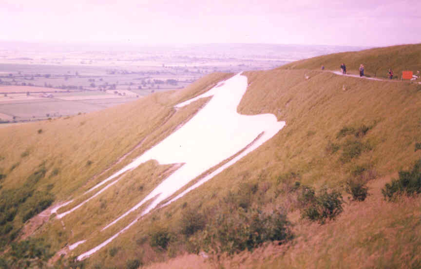
This
is another excellent site but nearer the bottom of the premier slope
league than St Agnes Head. The
Westbury White Horse can cope with winds from west to north with
a bit of east. It was once a hill fort and has a trench running
around the top which is handy to stand in out of the way of the
wind. The hill / ridge is some 350 - 400 feet high with a gentle
'run-in' at the bottom and a 'humped' top. The site overlooks the
flat plains of Wiltshire so other than a bit of turbulence generated
by nearby trees and buildings the air is very smooth when flying.
There is a cement works at the base of the ridge on the western
end and if flying from this area the air is laced with the smell
of sulphur. The site is again shared with hang gliders and para-gliders
not to mention visiting full size gliders from nearby Keevil airfield.
The full size gliders often appear frightenly low but I am sure
this is an optical illusion due to their size. Another hazard is
the pedestrians as the site is very popular with walkers. These
can be both an hazard and a distraction, particularly on windy days!
The site is also popular with kite flyers but these are not a problem
as they operate some distance away from the flying area.
Summary:
An excellent site, good clean lift, landing can be tricky due to
the 'humped' top and landing in lift. Watch out for the other users,
frequency control and over-flying other transmitters after an aborted
landing approach. As a personal recommendation I will regularly
drive a 100 miles to fly this slope.
|
Back to top
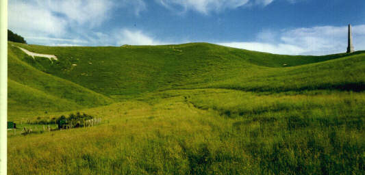
White
Sheet, Mere Wilts.
The
White Sheet is the home of the White Sheet club and is situated
just off the A303 near Mere in Wiltshire. It is a collection of
chalk hills rising above the Wiltshire plains. These slopes cover
almost any wind direction from due south around to east in a clockwise
direction although some sites are seldom used for a number of reasons
so please check with the White Sheet club first. The two main sites
are the SW bowl and the NW ridge. My favourite is the SW bowl and
I regularly drive the 85 miles to visit it when the wind is right.
The lift, when blowing directly into the bowl, is excellent but
it can be a little turbulent in very strong winds due to the trees
at the bottom of the slope. In light to medium winds it is brilliant
for inverted low passes a few inches off the ground. It also has
an excellent turbulent free landing area but beware of the wire
fence, it has shredded the odd model in the past. If the wind is
in the west to north quadrant I prefer to fly at Westbury White
Horse some 18 miles away. This comment will no doubt alienate me
with some of the White Horse flyers because they are justifiably
proud of this excellent site but as you are probably aware my favourite
tipple is small sport / fully aerobatic models and these require
better lift conditions than F3B or large scale gliders which they
tend to operate. Access once again is excellent with the flying
site some 50 yards from where the cars are parked so security and
carrying your clobber to the site is not a problem.
Summary:
A very good site but in football league terms only at the top of
division one. Frequency control is very good using a conventional
peg board which is stored at the Red Lion pub at the entrance to
the lane leading up to the site. A fluorescent red disc is displayed
opposite the pub when model flying is in progress. Another plus
is that there are no hang gliders or para-gliders to worry about.
Well worth a visit.
|
Back to top
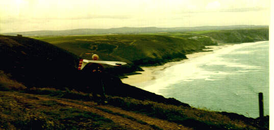
Dodman
Point, Cornwall
Dodman
Point is approximately 5 miles south west from Mevagissy on the
south coast of Cornwall. It is not easy to get to and I would strongly
advise taking an Ordnance Survey map with you (N0204 Landranger
series). It is a finger of land jutting out into the sea some 3-400
feet high. Dodman Point is best for east and south west but close
bu there is a long south east grassy ridge the hang gliders (and
modellers) use. The lift is, as you would expect from this type
of cliff site, excellent with the slightest breeze able to keep
most models in the air. The landing area is also excellent being
large pastureland fields. Very suitable for 1/4 and 1/3 scale models.
The SE ridge is very similar with possibly an even bigger landing
area. On the main ridges the model is launched from rising ground
30 yards or so inside the boundary fence so if things are not quite
right the model can be dumped before flying over the 'difficult
' terrain. On the east ridge it is possible to retrieve errant models
a long long way down the cliff slope. It is not a pleasant experience
though as the slope is covered in four feet high brambles and bracken
etc. If you do have to do it I recommend a hot bath laced with Tea
Tree and Lavender oil to heal the wounds! Dodman Point itself faces
due south and is about 100 yards wide and flyable but landing can
be a bit of a problem as where you fly is not suitable for landing
unless it is an EPP model (foamie)! There is however still the option
of wandering back from the ridge and landing in the fields behind.
On the right hand edge of the point there is a large monument erected,
if my memory serves me right, by a religious sect. The down side
of both locations is the walk to the site / car. For Dodman Point
the car is parked in the 'village' (six or so houses). There is
then a walk of a 1/4 mile or so to the ridges. For the south east
ridge the 'gear is dumped where you fly and the car is then parked
either end of the track as parking is not permitted in the unfenced
field. There is a nominal honesty parking charge of 50p.
Summary:
another excellent coastal site on a par with lift in the Premier
League but not as accessible as St Agnes Head. Well worth a visit
if on holiday in the area.
|
Back to top
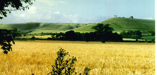
Cherril
White Horse - Calne Wiltshire.
The
Cherril White horse is a northerly facing chalk bowl rising above
the A4 east of Calne in Wiltshire. There is small hurricane savaged
beech coppice on the easterly end and a potentially model grabbing
obelisk on the western end. Parking is by the roadside with a 2-300
yard walk to the top that performs a 'Redex' style decoke to the
arteries. Not coronary inducing but sufficient to say 'I should
take more exercise'! Flying, when the wind is blowing due north
straight into the bowl, is excellent good. The site still works
when the wind is 15 to 20 degrees off to the east or west but due
to the lack of 'funnelling' the lift is obviously not so good. Landing
once again is best when the wind is due north as there is more than
ample room behind the slope. The main obstacles when landing is
the occasional grazing animal and the undulation of the terrain.
It is very easy to land in a small gulley and dislodge a wing or
tailplane.
Summary:
a good club site for northerly winds and one that leaves feeling
a little smug after climbing the hill. Well worth stopping for if
you happen to be passing with a model in the car and the wind just
happens to be in the right direction!
|
Back to top
Olivers
Castle (Roundway) Nr Devizes
This
site is situated a mile to the north off the A361 on the eastern
outskirts of Devizes. If approaching from the east you turn right
at the end of an old army camp by a caravan sales depot and follow
the lane, keep to the right at the first junction and left at the
fork in the road. If approaching from the west turn left a couple
of hundred yards past the Wiltshire police headquarters and do the
right left bit as before. The panoramic view of the Wiltshire countryside
is very pleasant consequently it is 'well walked'. The walkers are
not a problem as they pass behind you unlike Westbury where the
walkers pass in front of you and can be a distraction. Roundway
is where I did most of my 'baby sitting' when the children were
growing up. Well it gave my wife a break and cured the children
of any tendency towards agoraphobia! The site is quite can cope
with winds from south west around to north west although either
side of the point the lift is a bit patchy until it is established
on either the SW or NW slopes. There is a nice flat landing area
on the top with a couple of trees to help focus the mind at the
critical stage i.e. just before the model hits! The site is not
really suitable for large models that require a long glide in as
it is quite small but for small sports models is ideal.
Summary:
a very useful site for modellers living in the area or for those
on holiday nearby. The only points to watch out for are the trees
on landing and the sun in the summer evenings on the north slope.
|
Back to top
Black
Hill, Nr Haytor Rock Dartmoor.
As
I live in Devon I thought I better include one of my local sites
otherwise someone might accuse me betraying other flyers haunts
but keeping my own to myself! Black Hill can be found on Ordnance
Survey Map 191 north of Bovey Tracy and south west of Manaton. The
site is best approached from Bovey Tracy. Follow the signs for Haytor
Rock and when you can see the rock after the 2 - 3 mile climb turn
sharp right at some cottages and follow the road for about a mile.
Black Hill is over you left shoulder. If you make contact with the
cattle grid reverse up the road a hundred yards or so. It is not
a very big hill, 250 to 300 feet and can only cope with winds from
North to East. There is a bit of a climb to get to the top from
the road and when the wind is from the east it is one of those hills
that leaves you undecided as to where is the best place to fly from
as the gradient slackens towards the summit. It is also a bit of
a frustrating hill as quite often there can be a decent breeze but
the lift is poor yet on other occasions there can only be a nominal
breeze and yet the lift is excellent.
Summary:
Ideal on balmy summer evenings for practising landing approaches
and learning to fly towards yourself with 2 metre floaters. Again
another site worth visiting if you are in the area.
|
Back to top
|